USA

  • Haiku Stairs, Oahu — 4,000 Steps, a WWII Secret and the Trail They Could Not Close

    Haiku Stairs, Oahu — 4,000 Steps, a WWII Secret and the Trail They Could Not Close

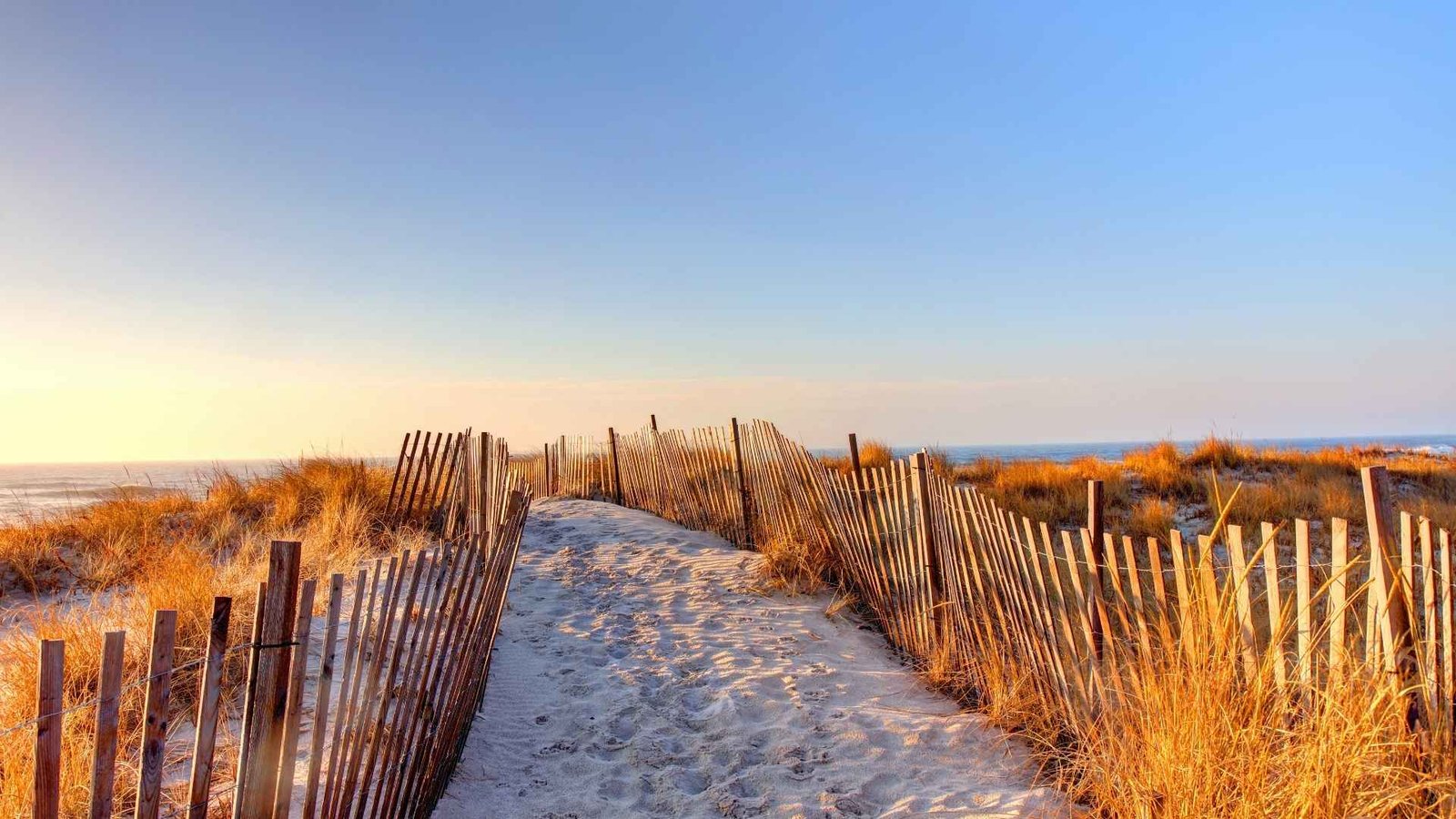
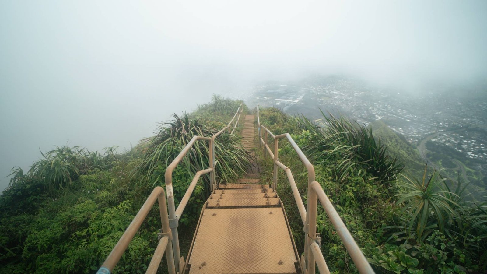
    Some places resist being visited on easy terms. The Haiku Stairs on Oahu are one of them. Known to most as the Stairway to Heaven, nearly 4,000 steel steps climb straight into the clouds above the Koʻolau mountain range — a ladder vanishing into mist, fenced off and officially closed since 1987. But there is another way up. It is longer, harder, and considerably more honest. And it is entirely legal.

    A secret radio station and a Pacific war story

    To understand the Haiku Stairs, you need to go back to 1942. The United States has entered the Second World War, and the Pacific is a theatre of war without visible boundaries. The Navy needs to communicate with submarines and surface ships across thousands of miles of open ocean — but conventional ground-level radio installations cannot reach far enough. The solution is found in the natural geography of northeast Oahu: the Haʻikū Valley, sheltered on three sides by mountains, with terrain that could give antenna arrays an elevation impossible anywhere else on the island.

    It was here that the original Haiku Stairs were constructed as a military access route leading toward the secret radio station high above the valley.

    Here, in secrecy, the Navy constructs the Haʻikū Radio Station — one of the most powerful military communications facilities of its era. Signals transmitted from this hidden valley reached ships and submarines operating throughout the entire Pacific region. The facility was top secret. No civilian access. To service the antennae mounted along the ridgeline, a set of wooden stairs was built directly up the cliff face in 1942 — steep, narrow, functional. They did the job.

    By the mid-1950s, the wooden steps were replaced with steel. Nearly 4,000 of them, bolted into the mountainside, with handrails and a pitch that remains relentlessly steep from bottom to top. Seen from the valley floor, the stairs disappear into low cloud. The name writes itself.

    Closed in 1987 — but not gone

    The radio station closed in 1987, and with it, public access to the stairs. Fencing went up. A guard was posted. The Haʻikū Stairs have since become one of Hawaii’s most contested attractions — or rather, the absence of one. Every year, thousands attempt to bypass the fence and make the ascent illegally. Every year, citations are issued, debates are held, and the question of who the stairs belong to — and what their future holds — remains politically unresolved.

    But there is a route to the top that requires no fence-jumping, no guard-evading, no citation risk. It is simply not easy.

    The Moanalua Ridge — the legal route from the back

    The Moanalua Ridge Trail begins in Moanalua Valley, a publicly accessible area, and climbs the Koʻolau ridgeline from the windward side. The route arrives at the summit from the opposite direction — at the tower and antenna ruins that still stand as geometric relics of a war secret most people have forgotten to keep. Technically, entirely legal. Just one of the harder hikes on the island.

    The distance is substantially longer than the direct Haiku Stairs route. The elevation gain is significant. And the ridge itself — the section that delivers the view and defines the experience — narrows at points to three feet across. Less than a metre of solid ground, with exposure on both sides: the ocean to one, the valley floor to the other, and wind arriving from directions the terrain cannot predict.

    This is the part of the unofficial Haiku Stairs hike that transforms the experience from a difficult trail into something psychologically demanding.

    The ropes, the rain and the mud waterfall

    Weather in the Koʻolau Mountains operates independently of whatever the forecast says for Honolulu. The ridge catches weather systems from both sides of the island. On the steepest section of the route — the pitch that requires fixed ropes to ascend — a sudden rainstorm can change the character of everything beneath your feet within minutes. Mud running down the rock face in sheets. Ropes worn smooth from the passage of hundreds of pairs of hands. Wind at 50 miles per hour pressing you sideways into the cliff.

    These are not dramatic embellishments. This is what happens. And it is precisely this element of uncontrolled difficulty that separates the Haʻikū experience from every other viewpoint on Oahu. When you finally stand at the summit and look down at the closed stairs disappearing into the clouds below you, you have done something that required something. That sits differently in the body than anything you merely saw.

    The view that earns its name

    On a clear day — and they exist, even on the Koʻolau — you can see both coastlines of Oahu simultaneously from the ridge. Honolulu and the southern shore to one side. The Windward Coast and the open Pacific to the other. The Haʻikū Valley below you like a green basin, the old radio station’s concrete foundations scattered through the vegetation like classified geometry. It is one of those views that does not photograph accurately. The width is too wide, the depth too far, and the light has a quality that only exists when you are standing in it.

    The stairs beneath you are closed. You came a different way. That makes it better.

    The uncertain future of the stairs

    The Haiku Stairs have sat in political limbo for decades. The City and County of Honolulu owns the structure. The State of Hawaii owns portions of the surrounding land. The United States Navy built the thing. And a growing number of residents in the Haʻikū neighbourhood are exhausted by the nightly procession of tourists who bypass the fence, get into difficulty on the descent, and knock on doors asking for help finding their way back to the road.

    A group called Friends of Haiku Stairs has spent years lobbying for a regulated reopening — with paid access permits, guided options, and structural upgrades to the older sections of the staircase. The conversation is active and genuinely contested. A managed reopening is not inconceivable. It is also not imminent. Until then, the Moanalua Ridge remains the only legitimate route for anyone wanting to reach the top without the legal consequences.

    There is something fitting about that. The stairs built for secrets are still surrounded by them. You can see them. You can stand beside them at the summit. But you cannot walk up them. It gives the ridge route a particular weight: you took the hard way because it was the only right way.

    The Hawaii that isn’t on the postcard

    The Koʻolau range is a different world from Waikiki. From the beach promenade, it is a silhouette — green, cloud-draped, decorative. Inside it, the range is one of North America’s most dramatic landscapes: near-vertical cliffs, forest that changes character every hundred metres of elevation, and rain that can start and stop three times in an hour. The journey from beach resort to serious mountain terrain is thirty minutes by car — one of Hawaii’s most underappreciated qualities for the traveller who wants both versions of the island in a single trip.

    Moanalua Valley itself is free and open to everyone. Hikers, families, local trail runners — the valley is no secret. It is the ridge above it that filters the casual from the committed. It does so efficiently.

    What you need to know before you go to Haiku Stairs

    Difficulty: Demanding to very demanding. This is not technical climbing, but it requires solid fitness, comfort with exposure, and experience on trails that are not groomed for casual visitors. Surfaces can be unstable and extremely slippery after rain — which should be assumed as a baseline condition rather than an exception.

    Distance and time: Expect a round trip of 10 to 14 kilometres depending on the specific route approach, with 5 to 8 hours on the trail. Start before sunrise if possible — the coolest and clearest conditions are in the early morning, and the middle of the day in the valley approaches can be punishing.

    Gear: Hiking footwear with grip on wet rock and mud is not optional. Bring gloves for the rope sections. A rain layer regardless of the morning forecast. Sufficient water for a full day and food for the return leg. Download an offline map before departure — mobile signal on the ridge is unreliable. Tell someone your expected return time.

    Season: The winter months (November through March) bring heavier rainfall and more frequent high winds. The summer can be clearer but hotter in the lower valley. Always check the forecast specifically for the Koʻolau Mountain Range — not for central Honolulu. They are different weather systems with different implications for the same day.

    Getting there: Moanalua Valley Park, ʻĀlewa Drive, Honolulu. Parking is limited and fills early on weekends. Rideshare from central Honolulu is the simplest approach. The trailhead is marked, but the full route requires GPS navigation — download the trail before you leave the hotel.

    Why this belongs on a traveltalk itinerary

    We do not usually write about places that require gripping muddy ropes to reach. But the Haiku Stairs are different. They carry a story that runs from a Pacific war fought in radio silence to a contemporary political argument about who owns access to natural heritage. They demand something physical. And they deliver a view that is not available to anyone who simply bought a ticket.

    For most visitors, Hawaii is Waikiki, luaus, and a Mai Tai at sunset. That version of the island is real and it is good. But the islands are also this: ridgelines with thousand-meter drops on both sides, forest that changes character every hundred meters of elevation, and places that carry stories about wars and secrets and the years when radio waves were the only thing holding the Pacific together. That Hawaii is not on the postcards. It is up the ridge, to the left.

    Read more about Hawaii on our complete travel guide

    Other media from Leisure Media Group

    • traveltalk.dk – Danish-language travel magazine covering destinations, hotels, airlines, cruises and travel inspiration from around the world
    • winetalk.dk – Danish-language wine magazine with extensive coverage of wine, gastronomy and food culture
    • worldsporttalk.com – international sports site covering top-level football, golf, tennis, Formula 1 and more from around the world
  • The Hamptons: what it actually is, and whether the journey is worth it

    The Hamptons: what it actually is, and whether the journey is worth it

    The Hamptons Beyond the Stereotypes

    The myth of the Hamptons is that it is a sealed enclave — a private beach for people who do not need to check prices, guarded by invisible social codes and accessible only by invitation. The reality begins on Route 27, the Montauk Highway: a two-lane road running east from Southampton through Bridgehampton to Montauk, with a CVS pharmacy in Bridgehampton, a hardware store in Amagansett, and a Dunkin’ Donuts in Hampton Bays. Everyone uses the same road. That is where the equality ends — but it also tells you that the Hamptons is not quite the sealed world its reputation suggests.

    Where it is and what it is

    The Hamptons are a collection of villages on the South Fork of Long Island’s East End, 80 to 130 miles east of Manhattan. The drive from the city takes between two and five hours depending on the day and time — the Long Island Expressway on a summer Friday afternoon is one of the more reliable forms of voluntary suffering available in the northeastern United States.

    By contrast, the Hampton Jitney coach service from 40th Street in Manhattan takes roughly the same time but costs around $35–50 each way and leaves the driving to someone else. The Long Island Rail Road from Penn Station runs directly to Southampton and East Hampton for about $25–35; a free on-demand electric shuttle called the Circuit connects the stations to the beaches and village centres. Going car-free is not just possible — it is the intelligent approach in July and August.

    The region divides into two township administrations — Southampton to the west, East Hampton to the east — and within those, a sequence of villages with distinct characters. The distance from Southampton Village to Montauk is about 45 miles, and that stretch contains enough variation to justify several separate trips.

    The beaches — actually among the best in the country

    The single most important fact about Hamptons beaches is that they are genuinely exceptional. This is not marketing. In 2025, Coopers Beach in Southampton Village was ranked the number one beach in the United States by the annual Dr. Beach survey — the same ranking it received in 2010. Main Beach in East Hampton came fifth nationally in the same assessment. These are Atlantic-facing, quartz-sand beaches several hundred yards wide, backed by native dune grass and — behind that — the kind of estates that do not appear on any rental market. The water is clean, the sand is white in the way that Long Island quartz sand is white, and the swells are real.

    What is complicated is the access. East Hampton Village operates a year-round beach permit system. A non-resident seasonal permit costs $750 and sells out within hours of going on sale on the first of February — 3,100 permits, allocated annually. Daily passes are available via the ParkMobile app at $50 per vehicle. Coopers Beach in Southampton operates separately: day parking runs $40–50 per vehicle. Atlantic Avenue Beach in Amagansett charges around $25. The free electric Circuit shuttle connects from the train station and main village streets to the beaches directly, eliminating the parking issue entirely for those arriving by rail. After September 15, most parking restrictions are lifted entirely and the beaches are free to access.

    The obvious conclusion: arriving by rail in September is the cleanest approach. The ocean water retains its summer warmth through October. The beaches are nearly empty. The parking is free. The prices in restaurants and hotels drop 15–30 percent. The Hamptons that locals actually prefer is the one after Labor Day.

    Five villages — five entirely different places

    Southampton Village is the oldest English settlement in New York State, founded in 1640. The social code here is old money and understatement — multigenerational wealth that does not need to advertise itself. The village has good restaurants, a walkable main street, and the Parrish Art Museum slightly to the west in Water Mill: a world-class collection of works by artists who lived and worked on the East End, including Jackson Pollock, Lee Krasner, Willem de Kooning, and Roy Lichtenstein. The private world of Southampton — the houses on Meadow Lane, the clubs, the invitation dinner — is genuinely private. What faces the public is welcoming and navigable.

    East Hampton Village is the cultural Hamptons — the art scene, the better restaurants, the celebrity adjacency. Nick and Toni’s on North Main Street has been the reliable social anchor for decades. Guild Hall runs serious arts programming year-round. The Maidstone Hotel is genuinely good. The paradox here is that the same village that contains some of the most expensive private land in America is also walkable, lively, and open to anyone who walks down the street. The hedge fund and tech wealth is newer than Southampton’s; the social performance is slightly more visible.

    Sag Harbor is what the Hamptons were before the money arrived, and what the money has not entirely displaced. A historic whaling village straddling both townships, it has a working-class origin — the sea captains’ houses in Greek Revival and Victorian styles are historical rather than decorative — and a year-round population that did not clear out when the summer season arrived.

    The Sag Harbor Cinema (rebuilt after a fire, now a community institution), the whaling museum, Bay Street Theater, Long Wharf, the independent bookshop: this is a real town. Herman Melville referenced Sag Harbor in the opening chapter of Moby Dick. The bay faces north, so the beaches are calm water rather than Atlantic surf — better for kayaking than swimming. Go to Sag Harbor to understand that the Hamptons has actual roots.

    Montauk is 45 minutes further east and functions as a separate destination. This is the surf and fishing end — the oldest lighthouse in New York State (commissioned by George Washington in 1792) at Montauk Point, the most dramatic dune landscapes on Long Island, a genuine commercial fishing fleet that goes out at 4 AM and is indifferent to the social season.

    The Surf Lodge opened around 2010 and accelerated the gentrification; the fishing boats are still there anyway. Montauk is less stratified socially than the western Hamptons, more democratic in atmosphere, and — for visitors who want to avoid the performative summer scene — the most honest place on the East End. Montauk Point State Park is free to enter and worth the trip on its own terms.

    Is the Hamptons only for the very wealthy?

    The honest answer: it depends what you mean by “visiting.”

    Renting a house for the summer season — the traditional Hamptons experience — is expensive by any measure. Entry-level three-bedroom rentals in Hampton Bays or Springs run to $50,000–75,000 for the full season, or $500–700 per night on the short-term market. The oceanfront properties on Meadow Lane are dynastic holdings that do not come to market. This is real, and it represents a closed world for most visitors.

    But visiting the Hamptons is a different proposition. A well-executed day trip — Hampton Jitney from Manhattan, Circuit shuttle to Main Beach, farm stand lunch at Pike Farms or Amber Waves, walk through Sag Harbor, train back in the evening — can come in comfortably under $100 per person. Hotels in Hampton Bays and Springs (East Hampton’s inland hamlet) run 30–40 percent below village-centre prices and provide easy access to everything. September is when the balance tips further in the visitor’s favour: warm ocean, empty beaches, lower prices, no social season pressure.

    The farm stands are not a budget compromise — they are one of the Hamptons’ genuine distinctions. Pike Farms in Sagaponack, Iacono Farm in East Hampton, Amber Waves in Amagansett: roadside produce in summer and early autumn at prices that have nothing to do with the surrounding real estate market. Silver Queen corn. Long Island tomatoes. Local duck. Loaves and Fishes in Sagaponack is the definitive gourmet prepared-food shop — founded by Anna Pump, who mentored Ina Garten — and expensive, but the kind of expensive that reflects actual quality rather than address.

    What is worth your time — and what is not

    Worth your time: Coopers Beach or Main Beach on a clear day. Sag Harbor at any time. The Parrish Art Museum. Montauk Point State Park. The North Fork wine country is a 45-minute drive north via the Shelter Island ferry — 60-plus wineries, working-farm atmosphere, completely different from the Hamptons social scene, and one of the better-value wine regions in the northeast. Pair it with a Hamptons stay or treat it as its own day trip.

    Not worth your time if you have limited days: attempting to drive in on a summer Friday, attempting to park at Main Beach without advance planning, attempting to experience both Southampton and Montauk in the same day. The geography is long and thin. The road gets congested. Choose a section and stay in it.

    The Hamptons International Film Festival in October runs for about a week from East Hampton Village — independent film, accessible tickets, a fraction of the summer crowd, and a genuine cultural event that has nothing to do with beach parking or property prices.

    Shinnecock Hills — where sport meets the landscape

    One component of the Hamptons that deserves its own paragraph: Shinnecock Hills Golf Club in Southampton is one of the founding member clubs of the United States Golf Association and has hosted the US Open four times. In June 2026, the US Open returns to Shinnecock Hills for the fifth time — making the week of June 18 an entirely different kind of reason to visit the East End.

    The course sits on glacial terrain above the Peconic Bay wetlands, and it is visible from the road in a way that most great courses are not. For a detailed account of the course and the 2026 championship, the sports coverage is at WorldSportTalk’s US Open 2026 guide. The two are genuinely worth combining: US Open week in the Hamptons is loud, social, and logistically demanding in ways that reward early planning.

    Practical notes

    Getting there: Hampton Jitney from 40th Street, Manhattan — $35–50 each way, drops at all main villages. LIRR Montauk Branch from Penn Station — $22–35, about 2 hours 15 minutes to Southampton. Circuit electric shuttle (free, app-based) for local movement once you arrive.

    When to go: September is the resident recommendation. July is the peak — warmest, most active, most expensive, most congested. May is underrated: local life resumed, prices moderate, beaches uncrowded.

    Where to stay: East Hampton Village for cultural activity and beach access. Hampton Bays for value. Montauk for surf, fishing, and landscape. Sag Harbor for the most genuine year-round atmosphere.

    The North Fork: The other prong of Long Island’s East End. Shelter Island ferry from Sag Harbor, 40 minutes north by car. Wine country, working farms, the village of Greenport. Completely different from the Hamptons social scene and worth at least a half day from any Hamptons base.

    The beaches: Book ParkMobile in advance if driving to East Hampton beaches in summer ($50/day). Consider the Circuit instead — free, reliable, and spares you the permit maze. After September 15: parking is free at most beaches.

    More beach trips here on Traveltalk.travel